The land tour: Aug. 1, Fairbanks area; Aug. 2, Bus to Denali (120 miles); Aug. 3&4 at Denali National Park; Aug. 5, visit Talkeetna; Aug. 6, By train, Talkeetna to Anchorage to Wittier to meet the Princess Star Cruise Ship. All these photographs are in a single collection.
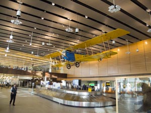 July 31: Frames 1-6, The Fairbanks Airport. We arrived in Fairbanks 8:30 pm Alaska time. We stayed in the Fairbanks Riverside Lodge. The land tour began on the next day, August first.
Aug. 1, Frames 7-63, The Alaska Pipeline, Gold Dredge and The Chena River tour.
Frames 7-16, All in the area of the Princess Riverside Lodge.
Frames 17-22, At the location of the Alaska Pipleline. Frame 21: Curious as to why I took this photograph? Notice the number on the support. A Civil Engineer understands this number. The number 23695+07 is the stationing from the beginning of the Alaska Pipeline. It represents the distance in feet, from the starting point for the Pipleline. Specifically, 2,369,507 feet from the starting point. It is 448.8 miles or 722.2 Km.
Frames 23-35, The train took us a very short distance to the location of Gold Dredge no. 8. We did pan for gold. I got a small amount of gold from my sample.
Frames 36-63, The Chena River Tour. Frames 42-48, these were taken at Susan Butcher's Kennel. She was the second woman to win the Iditarod. She won it four times. Her lead dog was Granite, she wrote a book about him. She died of Cancer at the age of 52. Her daughter, The spoke person in the photograph, continues her mother's tradition.
Frame 47, The dogs are running about 30 mph on the back stretch.
Frame 49, the Chena River joins the Tanana River not far from Fairbanks, this is the confluence.
Frame 50-63, These photographs were taken at a historic Athabascan Village site. Two young native Athabascan's provided the narration. The historic village presents the way the ancient Athabascans lived before the Europeans came into the interior of Alaska. The Athabascans adopted some of the technology from the Europeans. Frame 51, notice the Fish wheel in the Chena River. The Sockeye Salmon are running in the river.
To view a collection of photographs taken in the Faribanks area click on the link below.
The last photo taken in the Fairbanks area is on page 4,frame 63.
You can see the entire set of photographs from the land tour by continuing through the collection.
Fairbanks area Photographs. The last photo is on page 4, frame 63.
Click here To return to the home page.
 August 2, Frames 64-83, Traveled to Denali Princess Lodge.
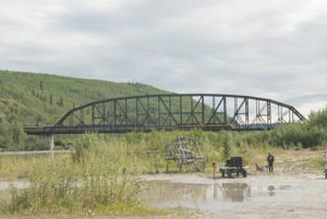
Frames 64-69, Stopped at the village of Nenana on the Nenana River.
Frame 64, Note the train crossing the bridge. It is an Alaska Railroad Train. On August 6, we will board this train to travel to Anchorage and on to Wittier.
Frame 70 & 71, Frame 70 is Horseshoe Lake and frame 71 is a beaver dam located at the end to the lake. This area is immediately adjacent to the Nenana River. It is an abandoned channel of the river. It is in Deanali National Park.
Frame 72, The only photograph that I took in the Denali National Park Visitor Center.
Frames 73-86, All photographs were taken on the grounds of the Denali Princess Lodge where we stayed. The river is the Nenana. You can hire the rafters and take a float trip on the Nenana River. The far shore of the river is in Denali National Park. Patrick, I think you would like to float this section. These photographs were taken about 30 feet from our front door at the lodge.
to view the photographs on the drive to Denali and on the grounds at the lodge, click on the link below.
The group starts on page 4, frame 64 and ends on page 5, frame 86.
Trip from Fairbanks to Denali National Park. The last frame is number 86, on page 5.
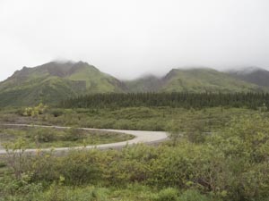 August 3, Frames 87-110, Taken during our 8.5 hour bus trip into Denali.
Frames 89& 90,Look carefully at frame 89, try to spot the Caribou. Frame 90 provides a better view. There are two bulls.
August 3, Frames 87-110, Taken during our 8.5 hour bus trip into Denali.
Frames 89& 90,Look carefully at frame 89, try to spot the Caribou. Frame 90 provides a better view. There are two bulls.
Frame 106, This is not a good photograph, but I included it because it is the best full view of a Moose that I got.
Frames 97 & 98, Very easy to spot the lone grizzly. In total we saw nine grizzlies.
Frames 101 & 102, This one is difficult. Frame 101, look carefully for the Caribou, there are six. Frame 102 makes it easier but still difficult to pick out all six.
Frames 103-104, Spot the Caribou. This group has cows with calves, a total of seven.
Frame 105, A single Bull Caribou.
Frames 107 & 108, Two Bull Moose, one in each photograph, The one in 107 is looking directly at the bus. The one in fram 108, all you can see is the shoulder area.
Frame 109, Nearly impossible to see the Bull Moose. Look just left of the Spruce in the middle distance of the photograph, you may be able to detect a slightly out of place color in the photograph.
Frame 110, Easy to spot, but a different Bull Moose.
It was difficult to get photographs on the trip through Denali. It was raining, the road was very wet. The wearing surface on the road consisted of crushed rock. Vehicle traffic had worn the crushed rock so there were considerable fines. These fines are referred to as rock flour. Due to the rain, the bus windows got covered with fine silt. Almost impossible to get a good photograph.
To jump to the Denali National Park photographs, click on the link below. You begin at page 4 of the collection. On page 4, start with photo 87, the last photograph of the set is frame 110, page 7.
The group of Denali National Park Photographs. The last photographs is frame 110, page 7.
 August 4, Travel by bus to Mt. Mckinley State Park (110 miles), Frames 111-113, Early morning at Denali Princess Lodge we will leave shortly for Mt. Mckinley Alaska State Park.
Frame 114, enroute taken from the bus.
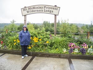
Frames 115 - 118, At Mt. Mckinley Princess Wilderness Lodge. After arriving we spent the rest of the day familiarizing ourselves with the layout of the Wilderness Lodge grounds. The places we have stayed at are pretty elaborate with beautiful grounds and a large number of structures.
The trip from Denali to Mt. Mckinley, see the text above for the details, In total, only 18 frames.
All photographs are on page 7, The first frame of the group, 111 the last, 118.
Denali to Mt. McKinley Alaska State Park, page 7, frames 111-118, click to view.
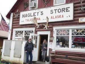 August 5, Talkeetna Frames 119-135: We took the bus to Talkeetna it is about 50 miles.
Frame 119, This is a potograph of one of the Alaska Railroad's diesels. Alaskan's can flag this train down in order to get a ride into town.
Frames 132 & 133, Three rivers come together at Talkeetna. They are the Susitna, Chulitna and the Talkeetna.The combined flow from these three rivers create a large river. All the rivers that we saw were glacier fed. As a result they carry a very large silt load. The water is very cloudy.
Frames 136 -138, Back at the lodge trying to get a photograph of Denali. If the mountain were visible it would be observed in either of frames 136 or 137. If you look carefully in frame 136, two-thirds of the way up in the frame and left of center, you can see, very faintly, one of the buttresses on Denali. I think you can see this buttress very faintly in frame 137. Frame 138 is to the right of Denali. The atmospheric conditions did produce some interesting effects.
The Talkeetna group of photos, begin on page 7, Frame 119, and end on page 8, frame 134.
The Talkeetna photos, click to view.
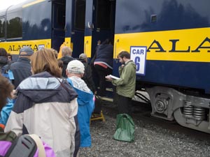 August 6, Frames 139-158, Boarded an Alaska Railway train in Talkeetna. Traveled by rail to Wasilla, Anchorage, and then to Wittier. The total mileage from Talkeetna to Wittier is about 180 miles. The distance from Anchoarage to Wittier is 50 miles. In Wittier we boarded the Princess Star.
Frame 139, We are boarding the train in Talkeetna. We traveled by bus to Talkeetna.
Frames 140-146, Scenery photographs taken from the train. Alaska is not short on water.
Frames 147-148, Leaving Anchorage and traveling along the Turnagain Arm of Cook Inlet. These two photographs show the mud flats in the inlet, the tide is out but is returning. Frame 147 shows a little water on the flat, while frame 148 shows not water. The train is traveling along the shore up the inlet. As the tide comes in, the water level rises 6 to 7 inches every two minutes. Anchorage has 25 foot tides. People get trapped on the mud flats and have to be rescued.
Frames 149 & 150, During the 9.5 magnitude Alaskan Earthquake (The highest magnitude earthquake ever recorded on the North American Continent) the ground dropped 6 to 8 feet in this area. As a result the ground water flooded the area and killed the trees. There are some remnant dead trees left. The area is now a marsh. Obviously the rail line had to be rebuilt.
Frame 151, This is a glacier just before you get to Wittier. In this area, there are two relatively long railroad tunnels that were built during World War II to provide access to the ice free harbor in Wittier. With the tunnels and railroad completed troops and equipment could be transported to Fairbanks.
Incidentally, both cars and trains share the same alignment through the tunnels. This train dispatcher controls the lights at the beginning to the tunnels. We had to stop for about ten minutes in order to allow the car traffic to clear the tunnels.
Frames 152 & 153 provide views of the Princess Star as we approached on the train. The train stopped on the wharf and walked across and boarded the ship. We left Talkeetna about 1:00 pm Alaska Time and boarded the ship about 7:00 pm Alaska Time.
Frames 154 - 157, The first two are views of the harbor from our patio. Frames 156 & 157 are taken from our patio, the ship is underway. We got underway about 8:30 pm Alaska Time.
Frme 158, (10:00 pm, Alaska time, August 6) Underway along the eastern edge of the Gulf of Alaska. The ship is exhibiting a very gentle roll. You certainly know it is present but it is not bothersome. Our speed is 20.0 mph.
A group of photographs associated with leaving Mt. Mckinley State Park and traveling to the ship in Wittier. Read the text above for full details.
The group begins on page 8, frame 135 and ends on page 9, frame 151.
By train, Talkeetna to Wittier, click to view the group of photographs.
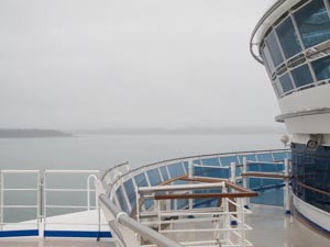
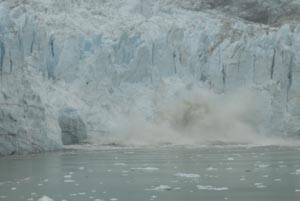
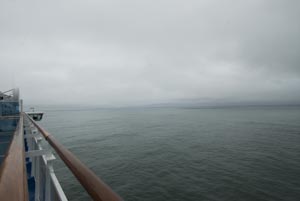 August 7, Out of Wittier, we sailed along the eastern edge of the Gulf of Alaska to Yakatat Bay (Yakatat Bay is located about 300 miles ESE of Wittier AK). We visited Turner and Hubbard Glaciers.
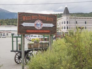 August 9, Skagway (frames 1-72): Early morning harbor scenes with cruise ships docking (frames 1-10). We boardedd the White Pass R.R. at the wharf and took the train to the top of the pass to Fraser, BC (frames 11-31). We had to show our passports at the border.
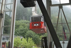 August 10, Juneau (frames 73-111): Harbor scenes from the ship (frames 73-79). Look carefully in frame 79, you will see the Tram to the top of the mountain. The day we visited was the 25th anniversary of the start of the tram.
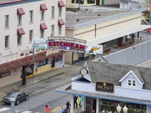 August 11, Ketchikan (frames 112-188): We docked in Ketchikan about 9:30 am. Ketchikan is located about 260 miles SSE of Juneau.
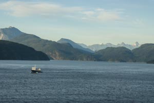 We left Ketchikan for Vancouver, BC about 5:30 pm Alaska time on August 11. It is 600 sea miles to Vancouver. We sailed all day on the 12th. We arrived in Vancouver at 6:40 am PDT on the 13th. The photo at the left was taken
about 8:00 pm on the 12th. Frames 1-32 were taken on August 12, Frames 33-45 were taken on August 13th all either entering Vancouver Harbor or at the dock.
We left Ketchikan for Vancouver, BC about 5:30 pm Alaska time on August 11. It is 600 sea miles to Vancouver. We sailed all day on the 12th. We arrived in Vancouver at 6:40 am PDT on the 13th. The photo at the left was taken
about 8:00 pm on the 12th. Frames 1-32 were taken on August 12, Frames 33-45 were taken on August 13th all either entering Vancouver Harbor or at the dock.